Sunday, October 24, 2010
Castella de Aguada/ Bandra Fort
One of the many forts in Mumbai, this one is located at the mouth of the Mithi river. Bandra fort along with the Mahim fort at the other side of river, once stood as strategic positions for the Portuguese.
Exact location is next to Taj Land's End.
I set out one Sunday morning just after sunrise with my cousin Nazeef to have a look. Photos are not that clear since they are from a cellphone.
The fort area is divided into 2 parts - the fort ruins and a garden.
I. Fort Area:
Not much of the fort remains. There is hardly any structure remaining; just an entrance, some walls and staircase.
Entire view of fort with the sea link in the background:
Labels:
bandra,
Castella de Aguada,
fort
Saturday, August 7, 2010
Kothligad Fort Trek
Also known as Kothaligad/ Peth fort. First a brief description.
Base Town: Karjat (well conected by rail/ road)
Base Village: Ambivali (150 metres)
Height: 620 metres
Difficulty level: Moderate (but somewhat dangerous in monsoon)
Time: 1 day trek (Although we took 3.5 hours for ascent and 3 hours for descent for various reason; I think it can be accomplished totally in 5 hours)
Food: At Ambivali you can get food at Sawant's house (the first house when you take turn to get into the village). At Peth, Sawant's brother does the food arrangement.
Accommodation: There is accomdoation available in Peth village.
Route: Vashi --> Panvel --> Karjat --> Ambivali --> Peth --> Kothaligad
- Vashi --> Karjat was covered by State Transport bus. (about 2 hours)
- Karjat --> Ambivali village, we hired a 6 seater (or TumTum as i colloquially used). Note that it is important to hire for entire day......as there is no means of transport available from Ambivali. He took Rs. 900 for dropping us at Ambivali and then taking us back to Karjat. (Time: 1 hour)
- Ambivali --> Peth village is a hilly ascent; although long but is made easy bcoz of the stony path that has been laid for the villagers. (2 hours)
- From Peth, the steep ascent begins to the mount of Kothaligad. (1.5 hours)
Sunday, February 28, 2010
Saturday, February 27, 2010
Panchgani Trek - Day 1
Luqman uncle planned for this trek alongwith Faraz and Taha.
Started from Mumbai on Friday night to goto Pune to join my relatives for trek.
Mumbai --> Pune --> Wai --> Panchgani Ravine Hotel --> Paragliding spot --> Electricity substation --> Dhom Road
We trekked from Panchgani electricity substation to some village near Dhom along the banks of river Krishna.
We were 8 people. So using 2 cars, started at 8.00 am from Pune. Reached Panchgani at about 11.00 am.
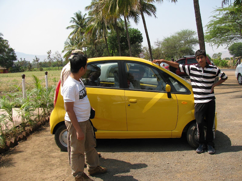
Celebrity Nano
My uncle (Munazzir) had newly purchased a Nano. Since that car is still a novelty, I decided to travel in that.
Saturday, January 2, 2010
Koraigad/ Korigad Fort Trek
Beginning the new year with a trek, how good is that !!!
How to get there?
Mumbai --> Lonavala --> Bushi Dam --> INS Shivaji --> Peth Shahpur village(2-4 kms before Amby Valley).
Once you are in Lonavala ask for the direction of Amby Valley since that village is very small and not famous. It is around 25 kms from Lonavala.
The total trek distance is quite small and you can cover it in an hour.
Caution: Depths in the photograph are greater than what they appear.
I still don't understand why hardly any of the photographs from the 4 digicams, reflect the true depths as we saw. Almost 90% of the pix have misleading depths.
The Village Trail
Best time to visit is winter. In summer, the heat will become unbearable since you have nearly a 2.5 km trail to cover on the top of fort without a single tree or any other shade. In rains, I think you will not be able to see anything at all from the top.
Caution: Depths in the photograph are greater than what they appear.
I still don't understand why hardly any of the photographs from the 4 digicams, reflect the true depths as we saw. Almost 90% of the pix have misleading depths.
The Village Trail
The trail begins near a school in the village. This part is stony and dusty and without much forest cover.
Subscribe to:
Posts (Atom)