Saturday, April 23, 2011

Unexplored Murud: The Khokri Tombs


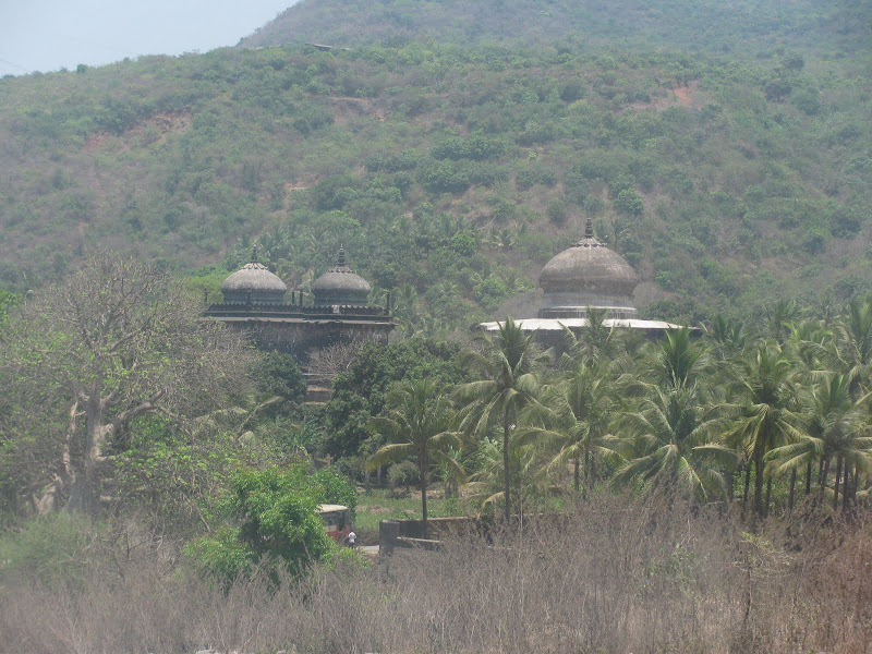
About 6 kms. from Murud-Janjira (and 1.5 kms. from Rajpuri) lies the Khokri (a.k.a Khokari) Tombs. They are just a km ahead from Rajpuri jetty where people board boats going to Janjira fort.

You will need to have your own vehicle to reach that place. Although you may get some local transport; you could struggle for the return journey since that place is secluded with no settlements nearby. Expect this to change after the construction of the Dighi-Agardanda port.

The tombs are of the earliest Siddis (probably the black African descendants). There are 3 major tombs  - One large and two smaller ones.


Unexplored Murud: Northern Part of Murud Beach


It's close to impossible that anyone who has been to Murud has missed it's beach. The Beach is about 2-3 kms in length flanked by cliffs with the Nawab's  Palace to the north and the Ekdaria river to the south.

However, most of the people visit the southern and central part of the beach; while ignoring th north. The main reason is because most places of stay and eateries are located there.
Good for me, I usually find this stretch to be empty even if its some holiday weekend.
I went to this beach just about at sunrise time. Sunrise is delayed thanks to the presence of a couple of hills in the east.

Photobucket

Friday, April 22, 2011

Unexplored Murud: The Nawab Siddi's Palace


On Friday I got an opportunity to explore the restricted palace from somewhat close distance thanks to the fact that the Nawab is some long-distance relative and Friday prayers are held in the Masjid inside.

I didn't explore the palace from inside and I think I made a big mistake of not seeking permission from the Nawab and losing this golden opportunity.

Anyways whatever I have explored is as follows:


The Masjid

The Masjid was earlier not used, but now the Nawab has opened it up for public. Many people come here for Friday prayers now.
There is one large tomb, next to the Masjid with some more graves behind. Probably this was the private graveyard of the Siddis.

Sunday, October 24, 2010

Castella de Aguada/ Bandra Fort


One of the many forts in Mumbai, this one is located at the mouth of the Mithi river. Bandra fort along with the Mahim fort at the other side of river, once stood as strategic positions for the Portuguese.
Exact location is next to Taj Land's End.


I set out one Sunday morning just after sunrise with my cousin Nazeef to have a look. Photos are not that clear since they are from a cellphone.
The fort area is divided into 2 parts - the fort ruins and a garden.


I. Fort Area:


Not much of the fort remains. There is hardly any structure remaining; just an entrance, some walls and staircase.


Entire view of fort with the sea link in the background:


Saturday, August 7, 2010

Kothligad Fort Trek


Also known as Kothaligad/ Peth fort. First a brief description.
Base Town: Karjat (well conected by rail/ road)
Base Village: Ambivali (150 metres)
Height: 620 metres
Difficulty level: Moderate (but somewhat dangerous in monsoon)
Time: 1 day trek (Although we took 3.5 hours for ascent and 3 hours for descent for various reason;  I think it can be accomplished totally in 5 hours)
Food: At Ambivali you can get food at Sawant's house (the first house when you take turn to get into the village). At Peth, Sawant's brother does the food arrangement. 
Accommodation: There is accomdoation available in Peth village.


Route: Vashi --> Panvel --> Karjat --> Ambivali --> Peth --> Kothaligad

  1. Vashi --> Karjat was covered by State Transport bus. (about 2 hours)
  2. Karjat --> Ambivali village, we hired a 6 seater (or TumTum as i colloquially used). Note that it is important to hire for entire day......as there is no means of transport available from Ambivali. He took Rs. 900 for dropping us at Ambivali and then taking us back to Karjat. (Time: 1 hour)
  3. Ambivali --> Peth village is a hilly ascent; although long but is made easy bcoz of the stony path that has been laid for the villagers. (2 hours)
  4. From Peth, the steep ascent begins to the mount of Kothaligad. (1.5 hours)

Sunday, February 28, 2010

Panchgani Trek - Day 2


Packing up

I woke up at around 07.00 am. Sunrise had happened but the sun had not risen thanks to the surrounding mountains.


Since the water wasn't so cleaned and had large amount of silts; none had ventured into it. But in the morning Ismail couldn't resist and took a holy dip in the river Krishna.

Saturday, February 27, 2010

Panchgani Trek - Day 1

Luqman uncle planned for this trek alongwith Faraz and Taha.
Started from Mumbai on Friday night to goto Pune to join my relatives for trek.

Mumbai --> Pune --> Wai --> Panchgani Ravine Hotel --> Paragliding spot --> Electricity substation --> Dhom Road

We trekked from Panchgani electricity substation to some village near Dhom along the banks of river Krishna.

We were 8 people. So using 2 cars, started at 8.00 am from Pune. Reached Panchgani at about 11.00 am.


Celebrity Nano

My uncle (Munazzir) had newly purchased a Nano. Since that car is still a novelty, I decided to travel in that.


Saturday, January 2, 2010

Koraigad/ Korigad Fort Trek


Beginning the new year with a trek, how good is that !!!

How to get there?


Mumbai --> Lonavala --> Bushi Dam --> INS Shivaji --> Peth Shahpur village(2-4 kms before Amby Valley).

Once you are in Lonavala ask for the direction of Amby Valley since that village is very small and not famous. It is around 25 kms from Lonavala.


The total trek distance is quite small and you can cover it in an hour.


Best time to visit is winter. In summer, the heat will become unbearable since you have nearly a 2.5 km trail to cover on the top of fort without a single tree or any other shade. In rains, I think you will not be able to see anything at all from the top.

Caution: Depths in the photograph are greater than what they appear.
I still don't understand why hardly any of the photographs from the 4 digicams, reflect the true depths as we saw. Almost 90% of the pix have misleading depths.


The Village Trail

The trail begins near a school in the village. This part is stony and dusty and without much forest cover.


Saturday, November 21, 2009

Hogenakkal Falls

Hogenakkal falls lie on the border of Karnataka and Tamil Nadu. It is a big gorge created by the river Cauveri.
Best time to visit is in summer; then the boat can pass from under the falls. In winter, you won't be able to go under. In rains, boating is closed.
Pravin and I started from Bangalore using public transport. Took a long time, around 4.5 hours. I would surely recommend that you hire a vehicle. That would save you around 1.5 hours and would cost you nearly the same. We want as follows showing changes of bus for entire route:
Bangalore -> Krishnagiri -> Hogenakkal -> Dharmapuri -> Bangalore


Fort in Krishnagiri


Monday, October 19, 2009

Alibaug Beach & Kolaba Fort


A wedding in Alibaug led to this planning. Although, I had planned to visit 3-4 beaches in that area, things always go wrong (Surprisingly in US, planning was damn accurate to a few minutes).
First, driver came late (9.30 am instead of planned 7 am).
Secondly, not everyone was so interested (after all it was a wedding).


Alibaug beach

Somewhat weird beach. The continental shelf is extremely flat, no noticeable slope. I think even if you go 4-5 kms from the coast, the depth won't be more than a metre.
When we reached, it was high tide and the water was nearly till the coast. We decided we'll go in water after playing for sometime.